

Art work at the Rail Park at 13th and Noble entrance. Pickering Spring Company sat where Baldwin Park is now.
One of the more curious landmarks in the Baldwin Park neighborhood is an open subway that stretches from Broad Street to 22nd Street. Known as "The Cut," it traces its origins from waterway, then to railway and, hopefully, to parkway.
William Penn had planned his city at the narrowest point between the Delaware River and the Schuylkill River, which allowed both river fronts to be developed at the same time. Most early development, however, was concentrated on the Delaware waterfront. In order to make a connection between the Delaware waterfront and the Schuylkill, a canal was proposed and developed in fits and starts. The original canal company began in 1792, after Robert Morris, the "financier of the American Revolution," purchased a right-of-way through Bush Hill. As an aside, he also owned "The Hills" mansion (now the site of Lemon Hill), and Morris Street ran east-west toward "The Hills" from Broad Street. It has since been renamed Spring Garden Street from river to river. See 1776 map here and 1810 map here.
This canal was to go from the Schuylkill River north of Fairemount (the current site of the Philadelphia Museum of Art) to the Delaware River. The western section of the canal was to link up to Cohonquonoque Creek, later called Pegg's Run, which was navigable from the Delaware to about the current 15th Street. You can see the shaded blocks denoting development in the map below and the western extent of Cohonquonoque Creek. Morris' ultimate ambition was a canal between the Delaware River and the Susquehanna River south of Harrisburg, using the Schuylkill River for much of the byway, a water route first proposed by William Penn 100 years earlier. Canals were necessary along rivers where there were rapids and waterfalls. These rapids were caused by the drop in water levels along the fall line between the piedmont plateau west of Philadelphia and the coastal plan to the east. The fall line runs right through Philadelphia. These falls were good for early industry that utilized the falling water to power the mills, but hindered transportation. For more geology see our article here.

Detail from Map of Philadelphia and parts adjacent, Nicholas Scull, 1777. From the American Philosophical Society

Philadelphia in 1702, looking west from the Delaware River.
Pegg's Run is the creek on the right.
(Library Company of Philadelphia)

Navigating up Pegg's (or Peg's) Run from the Delaware River (on right) just west of the bridge over Front Street. Just out of frame to the left, west of 2nd Street on the north side of the creek, would be John White's Bath, founded in 1765. It was basically a spa with luxury eats like chocolate and cream, and baths. Season passes could be purchased.

Detail, Map of Philadelphia 1797, John Hills (Athenaeum of Philadelphia))
Note proposed canal coming from upper left and passing south of Springettsbury Manor and Bush Hill, and Pegg's Run on right within east-west shading denoting a valley.
The canal never reached fruition, and poor Robert Morris ended up in debtors' prison for three years. The shallow depression that was to be used as a canal became a cart-way and then a railway in the 1830s, eventually stretching along the surface streets from the Delaware to the Schuylkill. Willow Street, which gently curves from Front to 9th Street currently, is the covered over remains of Pegg's Run. The railroad was laid over Willow Street to connect with the Reading line at Broad and Vine. More on Willow Street here. All the steam railway lines were north or south of the City proper due to bans on steam locomotive use within the City after 1838 in response to public protests of the dangers of the steam locomotives.

Philadelphia, 1856. J. H. Colton, NY
(Library of Congress)
Note winding Willow Street just north of Callowhill Street from Front Street to 10th Street where its name changes to James Street.

Sketch from 1876 of the intersection of Broad and Pennsylvania Avenue (just north of Callowhill Street). Photo credit here.

Article from The Philadelphia Inquirer on September 5, 1884.
The sketch above portrays the location of the accident in the article description, since Pennsylvania Avenue became Willow Street east of Broad Street. Caven Street was the short street which is now the driveway on the west side of the Tivoli Condominiums at 1900 Hamilton Street. Caven Street had its name changed to Opal Street in 1897 and then was officially stricken from the street grid at the request of I-T-E in 1975. As discussed in our article on the Dinan Funeral Home, 1843 Callowhill Street was the second business address for undertaker Frank Dinan.
The surface railroad amid all the industries that sprang up along its route became dangerous for carriage and pedestrian traffic. The sketches from 1893 below show the pre- and post-depression plan of the surface railroad line looking from Broad Street to the west.
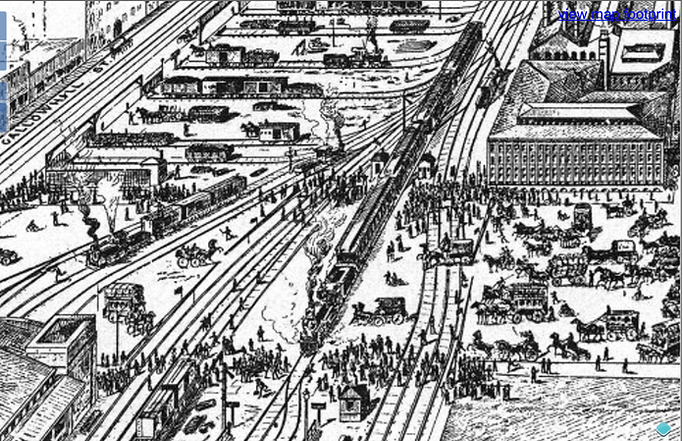
Looking west from Broad Street, with carriage and buggy traffic backed up north of Callowhill Street
(Athenaeum of Philadelphia)

Same location after planned open subway

This sketch for the subway shows the railroad siding leading under what is now the Tivoli condominiums between 19th and 20th and Hamilton and Cuyler Streets. Note also the street just west of what is now the Tivoli, Caven Street, running north-south, and the temporary track laid on Hamilton Street.

Sketch of the Stanley G. Flagg and Company Union Malleable Iron Works pre-1893 with surface railroad, and railroad siding entering factory, looking from the southwest. This site is now the Tivoli.

After 1898. The railroad siding now enters the factory at a lower level. The iron works was later replaced by a warehouse for American Stores, which was replaced by a surface parking lot, then the Tivoli.

Looking west at open subway from 19th Street in 1900. The wooden granary building on the left burned down in 1925 and was replaced with the current concrete granary. The siding under the current Tivoli is clearly seen on the right, as well as the connecting ramp up to the granary on the left.

2018 view with granary ramp, and the siding under the Tivoli partially filled in with stone and dirt.
This image shows two of the four methods of protecting transit operations for the industries along the Cut:
-
The granary. Forcing the Reading Railroad to acquire some property to build a ramp up to the building.
-
The Tivoli. Building a hydraulic lift under the building to lift a loaded railroad car up to the first floor. No loss of property.
-
Pickering Spring. Taking legal action to force the Reading Railroad to build a cantilevered steel structure alongside the factory to preserve a needed street frontage. A crane would be used to load and unload the railroad cars in the Cut.
-
The Sellers bridge. Acquiring land for a ramp on the opposite side of the Cut and then building a bridge across the Cut into the factory. In this case the land was acquired from the defunct Asa Whitney Wheel Works thus preserving the Sellers buildings.
Here are some other then-and-now scenes. For more on the engineering aspects of digging the open subway, see our article on the Pickering Spring factory here.

This view is from 16th Street looking west in 1898. The wooden granary is in the back left at 20th Street. The angled bridge into the William Sellers Company is still with us. You can also see the still existent ramps that brought freight cars up to and into the factories.

The same view as above but in 1940, just after completion of the Lit Brothers warehouse.

2018 scene from 16th Street looking west. The angled bridge connects nothing now.

1923 photo looking west from 21st Street bridge at east entrance of railroad tunnel. Ramp to Knickerbocker Ice Company on the left and the Philadelphia Museum of Art under construction in top left of image.

Same view in 2018. The overgrown ramp on the left behind the Barnes is the ramp to the previous Knickerbocker Ice Company. This site is now occupied by the 2100 Hamilton upscale condominiums.

Baldwin Park on left and Callowhill Cut in center of image, looking east, in 2014.
The abundant overgrowth in the Cut was cleared in 2015 prior to the Pope's visit.
The gravel area on the left side of the Cut is atop the cantilevered street that was built to preserve at-grade Pennsylvania Avenue for Pickering Spring. This area is behind the chain-link fence on the south side of Baldwin Park.
The grassy area on the right is discussed in our article here.
(photo courtesy of Jim Fennell and Paul Shay)
The last train down the Callowhill Cut was in 1992. Shortly afterwards, the length from 30th Street to 16th Street was sold to SEPTA. The two blocks from 16th to Broad Street had already been sold and are covered over with development.
The Callowhill Cut runs just to the south of Baldwin Park. With the completion of phase I of the Rail Park in June of 2018, we all hope that this new linear park will extend westward as planned and add to the excitement of the Baldwin Park neighborhood.
Further reading:
https://hiddencityphila.org/2012/06/origins-of-the-city-branch-canal-natural-man-made/
good summary from Harry K on the City Branch
https://www.phillyhistory.org/blog/index.php/2016/09/cracking-americas-ice-addiction/
Knickerbocker ice plant, the biggest in the world at the time
Part 1 of open subway development
Part 2 of open subway development
https://hiddencityphila.org/2018/02/riding-the-rails-on-pennsylvanias-original-turnpike/
City Branch of the Philadelphia and Columbia Railroad, Belmont inclined plane
authored by Joe Walsh
7/2018