
Pickering Spring
Just south of Matthias Baldwin Park is the open subway created in 1898 to lower the railroad tracks below street level. There is a curious iron structure near 18th Street. Why is it there?

Rusted overhang looking west from the 18th Street bridge over the Callowhill Cut.
On top is the former Pennsylvania Avenue that ran from 18th to 19th Street just south of the Pickering Spring Company. Under the overhang are the rails on the ramp that led up to the Baldwin Locomotive Works (BLW) boiler shop between 17th and 18th Street (now a Community College of Philadelphia parking garage).
First a primer on suspension systems in wheeled vehicles. Shocks from irregularities in the road or rail surface are transmitted to the chassis of the vehicle and thence to the freight or passengers riding on that chassis. A proper suspension system does three things: it provides a more comfortable ride for passengers; it prevents excess forces from damaging the structures of the vehicle; and it increases adhesion between the wheels and the road or rail surface. The suspension systems were of two types. Leaf springs were strips of metal arranged in layers that would flex when bumps were encountered then recoil back into shape. Coil springs were what we normally associate with the word "spring," and would compress and spring back over bumps. Whether a horse-drawn buggy, a car, a locomotive, or a rail car, suspension systems improve the ride and safety. Locomotives and rail cars were big business in our neighborhood in the 19th century, and Pickering Spring Company at the northwest corner of 18th and Pennsylvania Avenue was a major supplier of suspension systems.


Rail car leaf springs on the left and coil spring on the right. Each has its advantages and disadvantages.
In 1867 William Nichols and Charles Pickering bought a parcel of empty land at the northwest corner of 18th and Pennsylvania Avenue. With a rail line running along Pennsylvania Avenue right next to their building, this was a convenient location for their business of making suspension springs, mostly for street cars, railroad cars, and locomotives. In 1879 Nichols sold his interest to his partner, and Nichols & Pickering became simply the Pickering Spring Company. In 1885 Pickering sold the business to James and Frank Laying, who retained the name Pickering Spring Company. By 1898, output of product was 700 tons per week. When you consider that at least one ton of iron and one ton of coal are required to produce one ton of springs, the attraction of a location next to a heavy-duty rail line becomes clear.

Detail from 1895 Bromley map. 18th Street runs vertically on the right; 19th on the left. Tatlow Street runs through the center of the future Baldwin Park.
The tracks are lying on the surface of Pennsylvania Avenue before the Callowhill Cut open subway was constructed. At the northeast corner of 19th Street and Pennsylvania Avenue is the rowhome at 423 North 19th Street, which is the official address of Matthias Baldwin Park.
The Baldwin Park block straddling both sides of Tatlow Street was 80% residential in 1895; by 1945 there would be no houses on this block.

Photo from December of 1894 of the northeast corner of 19th and Pennsylvania Avenue. 423 North 19th Street is the corner building. Just beyond the sidewalk on the right, out of frame, would be four sets of railroad tracks. The billboards on the south wall would be seen by the passengers on the trains. There are two people combing through a table-box of coal on the 19th Street side, with window signage for Breyer's ice cream and a news box for the Philadelphia Item. The homes on 19th Street are quite attractive and large. There are five rowhomes of two stories running to the east on Pennsylvania Avenue. Just watch yourself as you step off that curb (in addition to the trolley tracks on 19th Street)!
Today the only steep-pitched dormered garret roofs in our neighborhood are at 316 and 318 North 19th Street and on Spring Garden Street.

Ad from the trade journal Modern Locomotive in 1900.
Despite the passage of the Sherman Antitrust Act in 1890, a group of spring makers, with a combined output of 95% of the nation's springs, consolidated in 1902. The Pickering Spring Company was folded into the new Pittsburgh-based Railway Steel Spring Company that same year. Shortly thereafter, Railway Steel Spring was acquired by the American Locomotive Company, itself a 1901 consolidation of seven locomotive manufacturers and the major competitor of the BLW in the 20th century. By 1907, springs were no longer being manufactured at the Pickering Spring site in Philadelphia.
Now, about that iron overhang visible from the 18th Street bridge. The City had determined that surface railroad tracks along Pennsylvania Avenue were a hazard to the residents of Philadelphia. The Reading Railroad wanted to build a new terminal at 12th and Market Street. The City agreed to authorize the construction of the new terminal if the Reading Railroad would pay half the costs for putting its tracks either above or below grade at all the street crossings near the center of the city. The projected cost: six million dollars total, which adjusted to today's dollars would be about 200 million dollars. The decision was made in 1894 to put the tracks from 13th to 22nd Street below grade in an open subway; in a tunnel from 27th to 22nd Street; and elevated above grade from 13th Street into the new terminal. The City used eminent domain to acquire land on either side of the open subway, but Pickering Spring brought suit against the City. Pickering was going to lose its street access on Pennsylvania Avenue and also part of its building in order to push the retaining wall to the north to allow a ramp up to the Baldwin shop between 17th and 18th Street. A compromise was reached in which the retaining wall would be built along the factory's southern wall, but an iron overhang would be built over the cut to accommodate a paved Pennsylvania Avenue at its original grade. It was three lanes wide along the Pickering plant, and narrowed to a single lane further west to 19th Street. This portion of Pennsylvania Avenue was officially vacated and struck from the City plans in March of 1955, at the request of the I-T-E Corporation that owned the parcel. That "street" is now the area beyond the fence on the south side of Baldwin Park.

Besides the noise and the flying embers, the trains posed a real risk to pedestrians, horse carts, and other conveyances. This Philadelphia Times article from August 20, 1893, describes a neighborhood man losing his left arm to a neighborhood train next to the future Baldwin Park. There were four tracks at this spot; he apparently only accounted for one.
In 1890 there were over 300 deaths due to trains within the City limits.


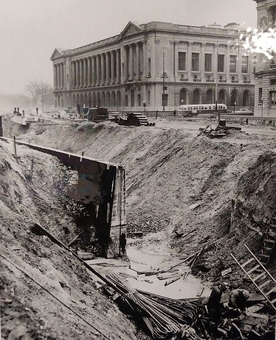
Looking north up 18th Street from just south of the new bridge over the Callowhill Cut in 1898.
The Pickering Spring Company seen on the left was in the southeast corner of the current Baldwin Park.
The inset shows the same view today with the same church spire in the background.

Photo from 1902 looking east showing the completed cut between 19th and 18th Street. The overhang covering the ramp is seen on the left and the start of the ramp up to the granary is on the right.
Photo credit here.

Photo looking west from the tracks near 18th Street circa 1902.
There were still rowhomes fronting the much-narrowed Pennsylvania Avenue seen at top right. The former wooden granary is in back left.
Roller skating was a new fad at the end of the 19th century. Along with a few purpose-built buildings for rinks, many ad hoc rinks were set up in armories, former factories, or open warehouses. The abandoned Pickering building became the Park Rolling Skating Rink. The source of the name is unclear, since it was a distance from the official entry into Fairmount Park at Green Street and no one then could have foreseen the future Baldwin Park. The name may harken back to the original name of Pennsylvania Avenue: Parke Street. According to the Philadelphia historic street name website, Parke Street was changed to Pennsylvania Street at an unknown time. Another possibility is that of a move from near the Fairmount Park entrance of a former Park Roller Skating Rink. On the iron art at the entrance to Phase I of the Rail Park, there is a representation of the neighborhoods along the rail cut as seen in 1895. Between 22nd and 23rd Street, just south of Callowhill Street, there is a Park Roller Skating Rink. According to the 1895 Bromley map here, that block was mostly residential with no rink building noted. Our rink may be that representation.

Park Roller Skating Rink in the former Pickering building as seen in 1907 during demolition of part of the retaining wall on the east side of the 18th Street bridge. The wall here was moved to the south along Callowhill Street to construct a train yard below grade.

This is a portion of a proposed plan for streets from 1833 with north to the right.
There was not much in the neighborhood then, except for the Bush Hill manor just to the left of the number 2. Parke Street is a surface street with a brand new railroad. It would become Pennsylvania Avenue. Wood Street and Callowhill had names that stuck. Fairview (now Buttonwood) and the other street names did not.

If you have not visited this amazing map in rusted iron at the Rail Park, please do.
There is some artistic license taken as to scale and exact locations, so this Park Roller Skating Rink between 22nd and 23rd Streets may represent the rink at the former Pickering Spring factory.
After the rink the Pickering Spring building became an automobile repair shop for Studebaker. Around the time of the Sanborn sketch below, and four blocks east, Studebaker was constructing two new buildings on North Broad Street. The one at 667 North Broad, built in 1916, was redeveloped in 2018 and is now commercial/office space with a vertical Studebaker sign facing Broad Street. The one at 800 North Broad, built in 1917, is now the People for People K-8 charter school.
The Pickering building was demolished around 1941 and the site was occupied by ancillary buildings of the I-T-E circuit breaker company in the 1940s through early 1970s. I-T-E was a significant landowner in the neighborhood when the Franklin Town project was announced in 1971. The I-T-E parcel between 18th and 19th and Hamilton and the Callowhill Cut became the site in 1991 of Franklin Town Park, which was renamed Matthias Baldwin Park in 2011.

Sanborn sketch from 1917 showing the former Pickering brick building.
Studebaker was a good fit with the neighborhood's history. It was founded in 1852 as a carriage maker before switching to gasoline powered cars in 1904.
In this sketch there are still rowhomes along the former Tatlow Street, called Noble Street in 1917.

Portion of the 1922 Bromley map showing the former Studebaker site now occupied by one of 100 branches the Chicago-based Thomas Cusack Company of America, which bought the two-story building in 1917. Ireland-born Cusack painted signs on buildings and did rooftop sign installations. He was known as "the Billboard baron," doing $22 million of business nationally in 1923, He sold the business in 1924 and died in 1926. I am not sure why the map references the Baldwin factory.
In more local Cusack news, in 1923 two teenagers robbed a car, led the police on a chase in our neighborhood, and crashed the car into the Cusack company after the driver of the stolen vehicle was shot in the head by police from the 9th District. He died within hours despite treatment at Garretson Hospital.

Portion of 1925 Aero Services aerial photo from the Free Library. The Studebaker shop is on the right just south of the eight-story Baldwin plant with the twin water tanks marked Baldwin. The Wolfington auto shop is to the north with the water tank marked Wolfington. The sign atop the five-story building at the left (now the site of the Tivoli) is marked
Robinson and Crawford
The House that Quality Built
and the water tank atop that building is marked ASCO, since it was serving as a warehouse for the American Stores Company, or Acme Markets.
423 North 19th Street and the other houses that are in what will become the southwest quadrant of the future Baldwin Park are in the center of this photo. The image is distorted on the right.

1928 photo from the west. North is to the left. The eight-story Baldwin Locomotive Works building with its two rooftop water tanks is in the center, occupying the northern half of the future Baldwin Park. The Pickering building with clerestory windows is to its south (right) with Pennsylvania Avenue running between the former Pickering building and the open subway. The road is wider on the 18th Street side, with parking on both sides plus a drive lane.
The three-year-old Reading granary with its signage is in the lower right.
There is a fun 25 Mb high-resolution copy of this photo here.

Photo taken in 1946 looking northeast towards what is now Baldwin Park. The eight-story I-T-E building, the former Baldwin shop, dominates what is to become the northern half of the park. A coal yard and other I-T-E buildings occupy the southern half. In the left foreground is 19th Street with its trolley tracks.
The Franklin Town project would demolish everything in this view.
There was another spring-related business along the Callowhill Cut route for 97 years, one with a still existing ghost sign. John Evans' Sons Inc. did not make rail springs, but did make springs of all sizes for carriages to fine machinery. It is on the southwest corner of 13th and Nectarine Streets. When the spring manufactory moved to Lansdale in 1967, the building served as a stable for tourist carriages before being converted into apartments with an overbuild.

The ghost sign on the 13th Street facade of the building existed in 2018 at the time of this photo, and still exists after the apartment conversion. The doors above street level are due to 13th Street being lowered in 1898 to allow the rail trestle to go over it just south of this photo. Photo credit Jim Fennell.
The story of Pickering Spring Company is fairly straightforward, so I thought I could write a little bit about the construction of the open subway. The section of the Callowhill Cut from 18th to 20th is a good place to look because everything is exposed and well-lit.
Below is a portion of the 1896 diagram for the proposed cut. The businesses, tracks, ramps, and grades are given. All of the businesses from 16th to 22nd Streets have their own dedicated pages on this website.

1896 overview diagram. Photo credit here.
There is a 33-page description of the Pennsylvania Avenue subway and tunnel in the Transactions of the American Society of Civil Engineers, volume 44, 1900 available here (dealing mostly with construction of the sewer system) and a 100-page review from the same journal volume 48, 1902, starting here. If you love engineering specifications, check them out.
Some homes and businesses along the cut had to be removed to place the retaining walls. For example, all the houses on the south side of the 1800 block of Pennsylvania Avenue were demolished. Others were close to the cut but salvageable. Their cut-facing walls might have needed underpinning or even some cutting away, but they were restored after the cut was completed. It is hard to realize the thickness of the retaining walls in place today, because only the top two or three feet are visible. The top stones are only 2.5 feet thick, but the wall itself has staggered thicknesses with the bottom layer being 12 feet thick. This thickness, plus the trenching needed to place these giant stones, required that up to 25 feet back from the finished wall might have been excavated.
The north and south retaining walls were built in broad trenches first, then the central core of the open subway was excavated. Digging was by picks, shovels, and steam shovels. Dirt was hauled away in rail cars on temporary tracks that were moved from surface street level to open subway track level as the trench deepened. The dirt was used elsewhere as fill on railroad construction.

The retaining walls are like icebergs; what you see at the surface is a small fraction of their mass. The walls go down 29 feet, with the top 24 feet visible today.
In the southeast corner of Baldwin Park, the base of the retaining wall in the very corner is projecting about twelve feet north under the pedestrian path.
Photo credit here.

Photo of the southern face of the BLW building at 18th and Pennsylvania Avenue in 1898. The building has been stripped of about six feet of its southern wall before the 29-foot deep trench is dug.

1898 photo looking west from 17th Street.
The retaining walls have been completed on both sides and the central core is being excavated.

Multiple starting points and multiple contractors pushed the tunnel project along, as described below.
Contracts were awarded by the block between the numbered streets. This allowed multiple contracting teams to work at the same time and later link their work. Amazingly, work was completed on the cut and tunnel in 21 months. The individual contracts were quite specific, even as to the type and origin of the quarried stone to be used on each block. Again, this allowed for a broader supply chain for the massive stones and prevented bottlenecks. The current photos below will show some of the masonry between 18th and 20th Streets.

The retaining wall under the 20th Street bridge showing finely dressed ashlar masonry using Clearfield County sandstone. The horizontal lines are all even across the structure and no small infill stones are required. Trolley lines ran on all the numbered streets in the neighborhood and the trolley operations were maintained during bridge construction.
Painful to today's ears would be the treatment of the "ceilings" of the underside of the bridges: two coats of white lead paint; covered by pine tongue-and-groove planks; then sealed with four coats of asbestos paint. Steam from the locomotives was bad for the steel beams of the bridge and the protective wood covering had to be itself protected from flying embers.

The French Creek granite making up the north wall between 18th and 19th Street. This rubble masonry, versus the ashlar masonry, is composed of irregular levels of joints and less worked corners on the stone.
The walls on this block have generally uniform large stones with few smaller filling stones. The stonework is not as tight as on the bridge abutments, but it has survived for 124 years and counting.
The overhang is at the far right. The wall gently curves to the north here to accommodate the tracks that went up the ramp under the overhang to the Baldwin Locomotive Works shop between 17th and 18th Streets.
The trees along the top are pulling up the concrete base of the railings (Philly 311 has been notified to no avail).

The Leiperville gneiss on the north wall between 19th and 20th Street.
The blocks seem less uniform, more uneven, with more small filling stones compared to the block to the east. Each was done by a different contractor.
The trees that were growing into the wall from the top were cut down in 2021.
Tommy tangent: Thomas Leiper was a revolutionary war hero who in 1809 constructed the first permanent railway. It used horses to pull cars over rails the 3/4 mile from his quarry on Crum Creek to navigable water on Ridley Creek in Delaware County. This is a stone's throw from the former Baldwin Locomotive Works plant in Eddystone.
The retaining walls have been in place for 124 years, a testament to the civil engineers who planned them and the laborers who built them. There is one obviously replaced section, that of the south wall between 18th and 19th Street, best viewed from the 19th Street bridge. The empty lot at 18th and Callowhill Street had been a transformer manufactory for decades, which contaminated the ground with toxic PCBs. Multiple attempts at soil remediation required digging down 18 feet near the wall, destabilizing the original retaining wall. A faux-stone replacement wall was inserted. This is discussed in our article here.

Replacement wall on the south side just east of the 19th Street bridge.
By my valuation of professions, plumbers rule the world. The tunnel, open subway, and elevated viaduct are amazing engineering accomplishments. Preceding work on those visible features, however, water drainage systems for the rail line had to be built. The existing sewers in 1896 were just below street grade, and drained by gravity into the Schuylkill River in the days before sewage treatment plants. These existing sewers were 24 feet above the bottom of the cut. For gravity drainage from a 24-foot-deep cut new conduits were dug out and tunneled in 1894 and 1895. Men created some open cuts and some tunnels to create space for a concrete underlayment with brick half pipes below and brick arches above to conduct the sewage. The previously existing sewage pipes draining the areas north of the cut were then connected to the new drainage system. The outlet of this entire system into the tidal Schuylkill River was only 5 inches above the low-water line, so it completely emptied for only a few hours per day. More on the sewer construction can be found in a 1900 article here.

These tunnels were hand dug, sometimes in tunnels where sewage flow had to be maintained. The tunneled sewer under Callowhill Street was six feet in diameter and 2,953 feet long. The only near catastrophe in the whole project was when the tunnel being dug under Callowhill Street collapsed at 19th Street due to the old sewer above the tunnel rupturing and filling the lower working tunnel with sewage.
Photo credit here.
Many creative ideas have been floated by neighbors for uses of the narrow strip south of Baldwin Park, the former Pennsylvania Avenue. Could it be a dog park? A pollinator garden? The problem with any use of this area is the danger involved with the rusted out iron supports on the east side of the strip and the precariously perched trees pulling the wall and railings apart on the west side.

Gaping hole through the roadbed and iron supports on the east side of the strip. It's a 24 foot drop!
The overhang frame was constructed of steel girders. A concrete base was applied then overlain with asphalt to finish the street. This hole goes through all layers.


More rusty iron.
The original railing along most of the Cut is still there, as shown here from the 1898 specs on the left and the juxtaposed current photo between 18th and 19th Street looking south. There is one decorative newel post remaining on this stretch of railing. The round pipe capping was replaced with a tented roof handrail that is extensively rusted through. The 2 inch channel at the bottom is embedded in concrete, but shows through where the concrete is damaged. The current photo is of the overhang which formed the street on the south side of Pickering Spring. Not a good idea to lean on that railing!
Left photo credit here.
There are very few artifacts for industrial archaeologists to discover in our neighborhood. The Sellers bridge between 16th and 17th Street is one. The wall of brick from the former Bement plant is another. When the south wall of the Pickering plant was reconstructed in 1898, it used the retaining wall as part of its foundation. From down in the cut the brick composing that south wall can be seen below the iron overhang.

Brickwork from the south wall of the Pickering plant atop the retaining wall beneath the iron overhang.
The southern part of our neighborhood exists on a mesa between two man-made canyons. The Callowhill Cut is a curiosity today because the absence of the railroad tracks, removed after 1992, conceals its original purpose. A block south of the Callowhill Cut is the Vine Street Expressway, another example of an open subway to prevent cross-street accidents and speed transportation, but this time for automobiles, not trains. The automobile subway took over 30 years to complete, in contrast to the train subway. For the history of the Vine Street Expressway see outside link here.
The "cut," this time for automobiles, being made down Vine Street in front of the Family Court building in 1957
Poured concrete and rebar is being used instead of massive stone blocks.
authored by Joe Walsh, May 2022