
The Community College of Philadelphia
There have been three dominant businesses in the Baldwin Park neighborhood over the last 200 years. Baldwin Locomotive Works was here from 1835 to 1928. I-T-E Corporation started out in our neighborhood at 19th and Hamilton Streets in 1900 and was a major landowner and employer here from the 1940’s until the 1970’s. For the last 50 years the dominant business has been the Community College of Philadelphia (CCP), with 1,200 employees. This article will remind us of what came before the CCP campus; the second article here will examine the changes over the more recent years. The history of CCP is available on Wikipedia, so these articles will focus on details of neighborhood interest.

The 14-acre main campus as seen today, looking to the west. The campus is between Spring Garden Street on the right and Callowhill Street on the left (north is to the right) and 16th and 18th Streets in Philadelphia. The parking garage in lower left, formerly used by GlaxoSmithKline, is owned by CCP and has the athletic courts and track on the roof. Matthias Baldwin Park adjoins the western edge of campus near the top of the image.
17th and 18th Centuries
For the following discussion, street names will be the modern names. Many of the streets didn’t exist in colonial times or had different names.
The future campus of CCP was peopled by the Lenni Lenape for thousands of years before Europeans came. And those very first Europeans did not include William Penn (1644-1718). The Dutch settled the area as early as 1623, and the Swedes followed in 1638. Along with the English, these three European nations fought over possession of the area until it was finally ceded to England in 1674. In order to satisfy a 16,000-pound-sterling debt to the father of William Penn, King Charles II in 1681 made Penn the proprietor of the land subsequently called Pennsylvania (plus Delaware and part of New Jersey). Penn was only in America for a total of about four years over two trips, but his representatives sold off parcels of land in shares or partial shares of 10,000-acre parcels. Most buyers were middle class, and almost all were Quakers. Most bought 125, 250, 500, or 1,000 acres each, at a cost of one pound for each fifty acres. Penn while in England had envisioned his city as encompassing 10,000 acres, but the first purchasers decided to make the city the current 1,200 acres (between Vine and Cedar/South Streets and between the Delaware and Schuylkill Rivers) and surround it by the Liberty Lands. Each purchaser received one acre in the City of Philadelphia for every 5,000 acres purchased, plus 100 acres in the Liberty Lands. Penn himself took a large parcel northwest of the city, running from 12th Street up to what is now Lemon Hill, as his own estate, called Springettsbury in honor of his first wife Gulielma Springett Penn.
Penn died in 1718. Philadelphia lawyer and statesman Andrew Hamilton (1676-1741) helped settle the Penn estate and was rewarded with a land parcel running from 12th to 19th Street and from Vine Street to Fairmount Avenue. He called his manor Bush Hill, and his grandson William Hamilton in 1737 built the manor house located on Buttonwood Street between 17th and 18th Streets. Meanwhile, Thomas Penn (1702-1775), the son of William Penn, lived in Philadelphia from 1732 to 1741. He built a manor house on Hamilton Street between 20th and 21st Street in 1737. The Penn family had little interest in the estate and sold off parcels, including a large parcel to Robert Morris. As detailed in our article on Morris, he himself ended up in debtors’ prison and the Springettsbury manor house became neglected and finally burned down in 1807. Bush Hill would be used as a patriotic gathering space for the city’s celebrations in 1789 and thereafter. From 1790 to 1791 Vice-president John Adams and family lived at Bush Hill for their first year in the temporary United States capital of Philadelphia. It was used by Stephen Girard and others as a hospital during the 1793 yellow fever epidemic. The subsequent histories of these two sites are discussed in our articles on the Gardens at Springettsbury and the Bush Hill Oil Cloth factory. After the America Revolution, the Pennsylvania state legislature purchased the Penn interest in Pennsylvania for 130,000 pounds and that ended the Penn story in Philadelphia. After the death of William Hamilton in 1813, the Bush Hill estate was subdivided and sold off.

Portion of the 1824 Drayton map: north is to the right. The link to the Drayton map provides better resolution.
It shows the Bush Hill area labeled with the number 2. The former Bush Hill manor house is just to the left of the number 2. Number 76 is the Bush Hill Hotel and number 384 is Macaulay’s oil cloth factory. Number 458 is the iron foundry of Rush and Muhlenburg. Number 104 is Coffee’s Steam Boiler Manufactory. There is little development seen, making the area ideal for large public institutions. Streets marked with dashed lines indicate proposed streets.
Around Northwest Square on the left is the Magdalen Asylum (building 307), the Widows’ Asylum (618), and the Orphans’ Asylum (381). These last three are mentioned in our article about Wills Eye Hospital here. The letters “PT” on the center right mark Penn Township. The City Hospital is the public hospital for the Spring Garden district, which had a northern boundary of Fairmount Avenue. The city of Spring Garden was incorporated in 1813, and in 1850 was the ninth-largest city by population in the United States.

This is a Per Cent for Art piece called The Freedom Ring located between the Winnet Building and the Athletic Center. Many of the people mentioned above are memorialized in stone, some more explicitly than others. On the left is spelled out Lenni Lenape and Philadelphia, the latter Penn’s given name to his new city. Gloria Dei Church, or Old Swedes’ Church, represents the Swedes. The Schuylkill River, named for the Dutch phrase “hidden river, flows in the foreground. All of these spiral into CCP near the center of the piece.
19th and Early 20th Centuries
Prior to 1820, the land that makes up the current CCP campus was free of buildings except for the Bush Hill manor buildings. This website has already posted articles about the other antecedent buildings on the CCP campus site:
-
Pavilion and West Buildings – Bush Hill Mansion, then an oil cloth factory; Bush Hill Brewery and the Spring Garden Library
-
Athletics Center – George Cresson Shafting Works
-
Bonnell Building – William Sellers Machine Shop
-
The parking garage with rooftop athletic courts on Callowhill Street between 16th and 17th – Asa Whitney Car Wheel Works

Portion of 1827 Siddell map of the subdivision of the Bush Hill estate (photo of map from the Historical Society of Pennsylvania). Morris Street (now Spring Garden Street) runs horizontally at the top and Hamilton Street horizontally at the bottom, with 18th Street vertically on the left. Isaac Macauley’s oil cloth factory, the Norris Locomotive Works, and the Bush Hill Iron Works of Evans, Rush, and Muhlenberg are seen running west to east on Morris Street at top. The home, and boiler manufactory, of Jonathan Coffee are seen at the northeast corner of 17th and Hamilton Streets. Coffee died in 1842.

The Hopkins map of 1875 below is centered on the current CCP campus, bounded by Spring Garden and Callowhill Streets and by 16th and 18th Streets. North is at the top.
The railroad tracks at this time were surface tracks down Pennsylvania Avenue (the Callowhill Cut would be dug in 1898). On the website there are articles on the Hoopes mansion, the Bush Hill Iron Works (formerly the site of Norris locomotives), the Sellers machine shops, Asa Whitney’s wheel works, Baldwin Locomotives, Cresson Shafting Works, and the Bush Hill Brewery. Everything in this 1875 “campus map” would be demolished.

The only business not previously discussed on the website is the lumber yard on the north side of Callowhill Street between 17th and 18th Streets. In the 1875 map above it is owned by Charles Este. By the time of this photo in 1898 it is owned by Richard Torpin. This is now the location of two parking garages and the Business and Industry Building.
Photo credit from Philadelphia, Pa. the book of its bourse and co-operating public bodies 1899

Photo from 1894 on the east side of 18th Street just south of the train tracks on Pennsylvania Avenue. This is now the site of the Center for Business and Industry building on campus. Most of these houses were boarding houses for the workers at the surrounding factories. Many of them, like today’s rental apartment buildings, had ground floor retail. The Frank Conrey Coal company sign on the left marks the front of 421 North 18th Street. Conrey himself lived at 1718 Spring Garden Street. Both business and home are now part of CCP’s campus. Joseph Charest had his shop at 413 North 18th Street, marked “Carpenter Shop” on the right.

Future CCP campus on 1901 Bromley map. Spring Garden Street runs horizontally at the top and 16th Street vertically on the right. North is at top.
The railroad tracks were placed below grade in an open subway in 1898 as discussed here. The Callowhill Cut in this image has been finished with a below grade freight yard in lower right. The lumber yard to its east (yellow represents buildings made of wood) would be demolished and the land excavated to extend the below-grade freight yard.

Architect of the Treasury William Martin Aiken designed the structure for the Third Philadelphia Mint and his successor, James Knox Taylor, constructed the building. It was completed in 1901.

This 1907 photo looking west towards the 18th Street bridge over the Callowhill Cut shows the excavation for the freight yard between 17th and 18th Street. The retaining wall on the left edge of the photo was incorporated into the One Franklin Town parking garage, as seen in the photo of the lower level below.

Photo from now: the lowest level of the parking garage with the 1898 retaining wall used as the foundation on the south side.

The future CCP campus in 1928 looking east. The Mint is in the upper left, somewhat brighter in appearance than the soot-covered factories of Baldwin and Sellers. Trucks could drive down the ramp on the south side of the freight yard and offload material from boxcars in the lower right. That freight yard would become the site of the parking garage for One Franklin Town.
Photo credit and high resolution here.
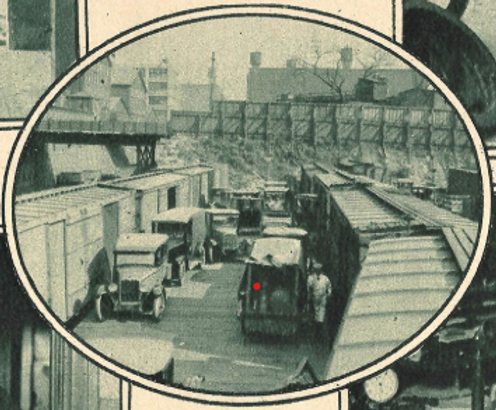
The trucks loading off the boxcars as seen in a Reading Railroad Magazine photo from 1925. This view is looking east.

1940 aerial photo looking northeast after the 1937 removal of the Baldwin Locomotive Works buildings. The Lit Brothers warehouse is under construction at left center and the land just north and east of it has been cleared of Baldwin buildings. The taller building just west (left) of the Mint is the Spring Garden Library (from the Free Library of Philadelphia archives).

The first structure built on the cleared Baldwin Locomotive Works land was this Lits Brothers warehouse. This photo is looking south on 17th Street in 1941 upon completion. This warehouse would be demolished in 1985 as part of the Franklin Town development and is now the site of a block-long CCP parking garage. Lit Brothers, coincidentally, had bought the Snellenberg department stores (first home of CCP) after the Center City closure of the main Snellenberg department store in 1963. Lit Brothers would itself dissolve in 1977.

1952 aerial photo looking east at the south half of the future CCP campus, all of it devoted to railroads and coal even in 1952. Vine Street is running vertically on the right. Part of the Family Court building is at lower center with Hallahan High School’s roof to its left (north). Besides those two buildings, the only other extant buildings are the Harrington Hoist factory (now the Lofts at Logan View Apartments) and the C. C. Knight building (now the 1600 Callowhill Apartments). The white storage silos for the George B. Newton & Co. coal company are at the northeast corner of 17th and Callowhill Streets, now the site of a parking garage owned by CCP but leased out. The angled bridge just to the left of the Newton silos allowed rail access into the William Sellers machine shop. That bridge is still there.
High resolution image here

Whether owned by Frank Conrey or George Newton or anyone else, horse-drawn coal carts were ubiquitous in the second half of the 19th century.
The George B. Newton & Co. had been around since 1874 and lasted into the 1950s: its coal delivery cart is seen here making a delivery just south of City Hall on Broad Street in 1905.
The tall West End Trust building is just south of City Hall in the background. The building to the left of the West End Trust building is Kugler's Restaurant. All of these would be demolished soon after this photo to make way for the Girard Bank complex.

A view looking west in 1948 at the future campus. North is to the right.
The William Sellers Company is south of the Mint Building down as far as the Callowhill Cut. There is a sign for the Sellers business on the lighter-colored five-story building with the water tower in the foreground. Photo from the Free Library of Philadelphia archives.

Portion of a 1962 land use map
The Mid-City American Legion Post No. 166 was at 1736 Spring Garden Street from 1949 until its purchase by CCP for $70,000. The Spring Garden Library was built in 1907 at 1700 Spring Garden Street. It was a Carnegie-funded public library built on land donated by the Baldwin Locomotive Works.

1907 photo of the new library from here.
This would have made a wonderful main administrative building for CCP if the Mint Building were not available.
The first community college in the neighborhood, and in the region, was a two-year college started by Temple University in its building complex on the 1800 block of Spring Garden Street, specifically 1808 Spring Garden Street. After World War II, two factors expanded the pipeline for post-high school education: the desires for career advancement on the part of returning GIs; and the availability of funds via the GI Bill. The Community College of Temple University prepared students for technical careers. The name went through several iterations but it was always a two-year school. It closed in the 1960s.

From the August 2, 1948 edition of The Philadelphia Inquirer
This article has looked at the former occupants of the land that was to become the CCP main campus. Part 2 will examine the origins and growth of CCP itself.
Further reading:
Colonial Era
1824 Drayton map of city
https://www.mapsofpa.com/19thcentury/1824-6653b.jpg 1824 Drayton map with prominent buildings
https://play.google.com/books/reader?id=qvEMnbhssKoC&pg=GBS.PP1&hl=en
1824 book text to accompany Drayton map with hundreds of building numbers.
https://archive.org/details/firstpurchaserso00penn/mode/1up 28-page booklet with reproductions of two parchment pages listing the first purchasers
CCP era
https://philadelphiaencyclopedia.org/essays/community-colleges/ Community Colleges’ history and Philadelphia area
https://www.myccp.online/sites/default/files/documents/FacilityMasterPlan/2013LandscapeVisionPlan.pdf 2013 CCP Landscape vision plan including rail park site
Published July 2024