
16th and Callowhill
Northeast Corner
The northeast corner of 16th and Callowhill Streets has been a surface parking lot for fifty years. This article will look at its past, and potentially its near future.

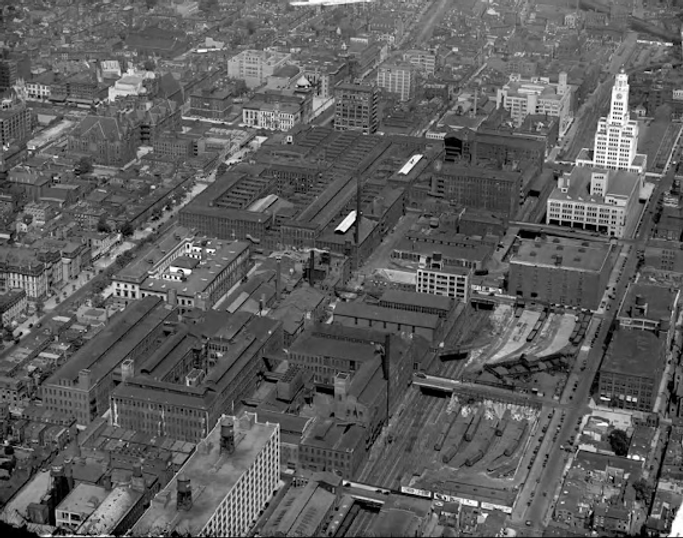
The pale surface parking lot at the northeast corner of 16th and Callowhill Street via Google Earth in 2025.
It is outlined in red. North is at the top and 16th Street runs vertically down the middle.
The CCP parking garage with rooftop track is to its west. The police parking garage is to its east. The surface lot rented by CBS in 1555 Hamilton is to its north. On the southwest corner is the 1600 Callowhill apartments. On the southeast corner are the ramps accessing the Vine Street Expressway.
In the lower left of this image can be seen some of the townhomes in the NOVOphilly development completed in 2021 just south of the Lofts at Logan View.

The northeast corner of 16th and Callowhill Streets in September 2025. The police parking garage is on the right, the Hamilton apartments in the yellow-trimmed towers, and CBS/KYW TV studios at the left edge.
This lot and the CBS lot just to its north are controlled by Philadelphia developer Bart Blatstein, who was the subject of a Philadelphia Inquirer article in March about unpaid taxes on these properties. As of September 15 the balance on the two lots was a combined $552,000, for which he has a payment plan with the City.
Neighborhood Buildable Lots
There are only a few empty building lots in our neighborhood, and some that could be easily emptied. The Community College of Philadelphia has two lots which are to be filled in on their 2017 Master Plan with a new academic building (on 17th Street) and an integrated health building (southeast corner of 18th and Spring Garden Street). The surface parking lot north of the Parkway Central Library has been suffering through spasms of development proposals but is currently in peaceful repose. Those lots are all City properties. There is an underused half-acre owned by the Flynn Company just east of the new NOVOphilly townhomes that has two empty lots bookending a two-story office building built in 1940. The two-acre building and surface lot for the Target at 20th and Pennsylvania Avenue will no doubt be a mid-rise apartment building with first floor retail someday, as it is zoned CMX-4. An adventurous development could be set in the grassy fields within the access ramps on the south side of the 1500 block of Callowhill Street. It is owned by PennDOT and is zoned CMX-4 per the chart on page 13 of the Logan Square Parkway Neighborhood Plan Update of 2019. The low-hanging development fruit seems to be the unpaved empty lot at the northwest corner of 18th and Callowhill Streets. It is fenced and functioning as just a (slightly contaminated) grassy field, not even as a surface parking lot.
That last parcel at 18th and Callowhill is owned since 1997 by 82-year-old Michael Karp, who runs student-leasing real estate firm University City Housing. Recent articles on this website talked about neighborhood folks who own the most individual parcels today (Michael Maltepes of the Rose Tattoo) and in the past (Gertrude Phelan who owned the block underneath the Granary Apartments from the 1940s to 1986). Michael Karp, with his 2024 purchase for $15 million total of both the Hallahan High School building on 19th Street and the linked Cathedral Parochial School on 18th Street, now owns the most acreage in the neighborhood (excluding the City and non-Philadelphia corporate owners). The lots for these two school buildings total 34,523 sf, which when combined with his empty lot of 51,922 sf at 18th and Callowhill give him almost two acres of land in the neighborhood. The Belmont Charter Network, with Michael Karp as its board chairman, is using the old Hallahan High School building as a public charter high school as of September 2025. He also made news in September when he purchased fifteen buildings at the former University of the Sciences campus in West Philadelphia.
Back to the Northeast Corner of 16th and Callowhill Streets.
A quick summary of its pre-19th century history:
The Lenni Lenape and their ancestors occupied the lower Delaware valley for millennia before the Europeans arrived. From 1682 to 1787 William Penn and his family owned the land just north of Vine Street extending from 19th Street to Lemon Hill. In 1737 his son Thomas Penn built Springettsbury Manor near the location of today's City View Condominiums. Penn's estate was sold to Robert Morris in 1787 and the manor burned down in 1794. Morris went bankrupt and his land was sold off in parcels. Springettsbury originally had included the land east to 12th Street, but in 1718, after William Penn's death, his widow Hannah Callowhill Penn gave Andrew Hamilton a portion of Springettsbury for legal work done in settling Penn's estate. Hamilton purchased adjacent land for a total of 153 acres, and called the estate Bush Hill, extending from 12th to 19th Street and from Vine to Coates (now Fairmount) Street. He built his manor house on what is now the south side of the 1700 block of Spring Garden Street, today part of the Community College of Philadelphia. As discussed in our article about the Graham/Laird silk factory, the Bush Hill estate was subdivided after the death of William Hamilton in 1813. The Bush Hill manor itself is discussed in our article here.
The equivalent of today's Center City did not extend much further west than Independence Hall at the time Bush Hill was subdivided, but when Matthias Baldwin moved his factory to Broad and Hamilton Street in 1835, housing for his expanding workforce gradually followed. By 1859 the 1600 block of Callowhill Street was completely built out, mostly with three-story single-family houses accommodating first-floor retail.
The history over the next 160 years will be told in the following images.

Portion of an 1849 map. The northeast corner of 16th and Callowhill is boxed in orange. There were already a good number of buildings on the lot. Railroad tracks run east down Pennsylvania Avenue and turn south on Broad Street to the station at Broad and Vine Streets (steam locomotives being banned from the City of Philadelphia).
Note: East-west street names often changed across Broad Street.
The first generation of metal workers in the neighborhood included Matthias Baldwin (at Broad and Hamilton in 1835), Norris Locomotive (moved to 17th and what is now Spring Garden in 1836), and William P. Cresson (at 13th and Hamilton in 1847). William Cresson was the father of George V. Cresson, who would open the Philadelphia Shafting Works at 18th and Hamilton in 1866. Asa Whitney would open his wheel works in 1849 on the north side of the 1600 block of Callowhill Street.

Portion of the Hopkins map of 1875 with north at the top, Callowhill Street on the bottom, and 15th Street on the right edge.
The railroad tracks at this time were surface tracks down Pennsylvania Avenue (the Callowhill Cut would be dug in 1898). On the website there are articles on the Sellers machine shops, Asa Whitney’s wheel works, Baldwin Locomotives, and the Cresson Shafting Work. The houses seen along Callowhill and 16th Streets were built in the 1850s.
The R. W. Patrick Coal Company moved to 1517 Callowhill from Broad Street when the railroad tracks on Broad were ripped up. The leftmost spur from Pennsylvania Avenue goes to his yard. Robert Arthur and Brother Coal likewise moved from Broad to the location of the other spur. Business names changed every few years in the coal business.
Everything in this 1875 map would eventually be demolished.

Clever Christmas marketing!
When I was a kid, the naughty children were threatened with a lump of coal in their Christmas stockings. Apparently, a ton of coal was a great gift in 1866. And only the best blends of the anthracite stuff.

All of these houses, only 20-30 years old, were removed in the early 1880s to make even more coal yards. These addresses may be reborn in the next year or so (see below).
The Philadelphia and Reading Railroad (PRRR) had bought up all the land and buildings between Broad and 16th and between Callowhill and Pennsylvania Avenue during the period 1866-1880 in order to expand its railroad freight yard. In 1890 the PRRR sold the northeast corner (192 feet on 16th Street and 137 feet on Callowhill Street) to the Pennsylvania Warehousing and Safe Deposit Company.

Portion of an 1888 Baist map with Broad Street vertically on the right and Callowhill running horizontally on bottom and Hamilton Street at the top, showing the houses at the corner being replaced by coal yards with a total capacity on the block of 10,000 tons of coal. The machine shop at the southwest corner of 15th and the railroad tracks on Pennsylvania Avenue belongs to the Edwin Harrington & Son Company Machine Tool Works as discussed in our article here. The Hide and Tallow Mfy. would become the American Grease Company at 1524-28 Hamilton Street. The iron foundry at 1516-20 Hamilton Street is that of Goodell and Waters discussed below.

Detail from 1895 Bromley map here. A warehouse for the Pennsylvania Warehouse Company has filled in the corner.

Pennsylvania Warehousing Company, 1894, NE corner of 16th and Callowhill Streets.

1885 lithograph showing the Pennsylvania Warehousing and Safe Deposit Company in what had been the First Bank of the United States. The company was founded in 1872 and still exists with its headquarters in Lower Gwynedd, Pennsylvania. It owns and operates warehouses.
The building in this image also still exists and is being remodeled as a museum of finance.

SE corner 16th and Callowhill, 1894.
The building on the far right bears the name Continental Market at its top. That site is now occupied by 1600 Callowhill Apartments in a building on the Philadelphia Register of Historic Places.
The structures along the south side of the 1500 block of Callowhill Street would be demolished in the early 1970s to construct the on- and off-ramps for the Vine Street Expressway in the 1980s.

Sketch of the 1894 proposal to drop the tracks below grade. The 16th and Callowhill warehouse is in the left background with two blocks of freight yard extending to Broad Street in the foreground. The Baldwin Locomotive Works is in the right foreground.
Photo credit here.
Currently SEPTA owns the right-of-way in the Callowhill Cut from 27th to 16th Street. The Cut between 16th and Broad Street was sold off to private developers and has been built in (partially) and over (almost completely).

The north side of the warehouse in 1912. A ramp brought goods up to the warehouse from the below-grade freight yard. The warehouse was built a few years before the Callowhill Cut was completed in 1898. Like all the pre-1898 buildings along the Cut, ramps (as at the granary), tunnels and lifts (as at what is now the Tivoli), or ramps and bridges (as at William Sellers) had to be constructed up to street level.
On the right can be seen the Goodell and Waters Iron Foundry in this location since 1870 (outside link here). An ancillary manufactory for its woodworking machinery was at 31st and Chestnut Streets. Mergers and dissolutions of mergers made Creswell and Waters a brief entity. The Creswell was David Creswell, who was related to the namesake of the Samuel J. Creswell Iron Works (1835-1985) that had been at 23rd and Cherry Streets across from what is now the Giant Market. The family of Robert Bernstein was partial owner of the Creswell Iron Works and that family figures in our article on the nearby Harrington Hoist building (now the Lofts at Logan View). You can find a Samuel J. Creswell Iron Works manhole cover in front of the Tivoli on 19th Street.

Portion of a 1922 Bromley map showing the warehouse surrounded by railroad tracks and coal supplies. The Baldwin Locomotive Works is at top right. It will be moved completely out of the neighborhood by 1928. The diagonal bridge over the Callowhill Cut into the Sellers plant can be seen on the left. That is the only extant structure north of Callowhill Street on the map.
The McIlvaine Brothers Spice Mill was a business that made all sorts of powders, from pharmaceuticals to explosives. Brothers Henry (1838-1900) and Abraham (1847-1918) lived in Powelton Village in West Philadelphia. Abraham's two sons, Herbert and Donald, incorporated the firm in 1921 as the McIlvaine Brothers Inc. It went out of business in 1931 and the building was demolished in 1932, around the time that the Baldwin Locomotive Works buildings were also being torn down.
Aerial view in 1928 of the 16th and Callowhill warehouse just west of the Inquirer Building and its production wing. West of the warehouse is the below grade freight yard.
Baldwin Locomotive Works is seen north of the warehouse ten years before its demolition.
1600 Callowhill is seen at far right middle with a water tower on its roof. The coal pockets are just left (north) of what is now The Lofts at Logan Square. These open bins will later be made into cylindrical silos.
The angled bridge over the Callowhill Cut between 16th and 17th Streets, to the left of the coal bins, still exists and is the last remnant of William Sellers' machine shop.
Photo credit Library Company of Philadelphia.

Photo from 1924 of the construction of the Elverson Building (the Inquirer Building and now police headquarters). This shows the freight yard on Callowhill Street between 15th and 16th Streets. Recent examples in our neighborhood of building using air rights over the Cut are the condo building at 2100 Hamilton Street as well as the Target and its parking lot at 20th and Pennsylvania Avenue. The condos in the mid-rise at 2100 Hamilton sold for $2.3 million to $5.6 million. The police parking garage at 15th and Callowhill and the lot at the northeast corner of 16th and Callowhill are built over the pictured freight yard now. The last trains down the Callowhill Cut in 1992 carried huge rolls of blank newspaper to the Inquirer Building.
Photo credit here.

Looking in the other direction: Aerial view looking west from about 16th Street in 1940.
This shows the western extent of the below grade freight yard. The sign for ELPECo in the distance is for the Electric Power Equipment Company which was on 18th Street in the northern half of what is now an empty lot. The freight yard started there at 18th Street and extended to Broad Street. Also seen here on the right is the new in 1940 Lit Brothers warehouse and the diagonal bridge that runs into the Sellers machine shop. That bridge is still there. The concrete granary built in 1925 is the tall structure on the south side of the tracks in the background. The structure just beyond the Lit Brothers warehouse is the eight-story Baldwin Locomotive Works building constructed as a munitions plant in 1916.
Astute rail enthusiasts may note the narrow raised tracks straddling two standard gauge tracks in the left foreground of this image, explained in the next image.

Image from a 1927 Reading Magazine article on the new 30-ton crane at the 16th and Callowhill freight yard. This was a gantry crane capable of moving 165 feet along the parallel tracks. The hoist could move 60 feet from side-to-side. It was built by a division of Bement-Niles-Pond which was at 20th and Callowhill, now the location of the Target store. It is interesting that the 50-ton crane placed at the 20th and Hamilton freight yards was built by the Sellers company at 16th and Hamilton.

Nameplate touts our neighborhood involvement in the electric traveling crane business.
Outside our neighborhood.
Pennsylvania Warehousing at 23rd and Arch in 1931, looking north. The company's 22 warehouses were concentrated near docks and railroad freight yards and were basically 19th century self-storage units scattered around the city.
This site is now home to an apartment tower with a Giant Market on the lower floor.

Portion of a 1942 land use map showing the corner occupied by a boiler maker.
The John Wood Manufacturing Company, started in Valley Forge in 1867, is a national firm that still exists. In 1918 it had been at 1223 Hamilton Street before moving into this larger building.
Even though the warehouse was just outside the footprint of the Franklin Town development announced in 1971, it was demolished in the late 1970s like most of the buildings within the footprint.

16th Street Store building still there on the left in 1955, looking east down Callowhill from 16th Street

One last view of the past, looking west from the corner of 15th and Callowhill Street in 1961. The warehouse is in the back right.

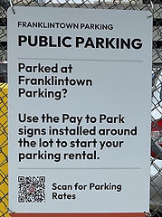
The corner parking lot at 16th and Callowhill is now public parking. Until five years ago it was used as employee and business truck parking for CBS TV and KYW radio, until KYW Radio moved to 2400 Market Street in 2020. The adjacent half-acre surface parking lot to its north is still parking for CBS and as of August 2025 is for sale (for $19 million!). It is zoned CMX-4 and currently assessed at $9 million.
The sign on the fence calls the lot FranklinTown Parking. This is wrong on three counts: the 1971 project was called Franklin Town, not Franklintown; this corner was not within the footprint of the Franklin Town project; no one in the neighborhood calls it the Franklin Town neighborhood. It's the Baldwin Park neighborhood. The Friends group worked to get the park name changed from Franklin Town Park to Matthias Baldwin Park, as discussed here.
It will be interesting to see if the proposed development of million-dollar homes as seen below will tolerate having Rosa's Photo and Fingerprinting parked opposite their driveway entrance.
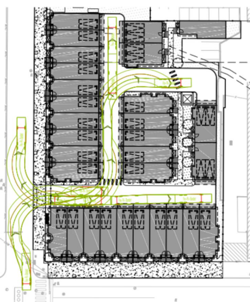
North is at top.
Part of the August 2025 permit application for a new townhouse development from land owners Callowhill Partners LLC. The official address for the project is 1527-1547 Callowhill Street. Colliers Engineering and Design of Philadelphia, the same firm that did the site work for the Hamilton Apartments just northeast of this site, drew up the plans (Colliers also manages the 1.2 million square foot office building at 1500 Spring Garden Street).
There are six buildings, with ten four-story homes on both Callowhill Street (along the bottom) and 16th Street (vertically on the left), all of which have one-car parking. There are two homes with two-car parking, five with one-car parking, and one without parking within the development. They are accessible by the two-way driveway. All garages will have EV chargers.
The houses are mostly 3,000 square feet. The lot itself, zoned CMX-4, is just under one acre and is assessed at $16 million.
The Callowhill Cut is covered over on the northern edge of the property.
Even if this particular proposal is not realized, no doubt something similar or a high-rise tower will eventually fill in this corner.
There are pros and cons to a low-density development with individual homeowners and an HOA. As discussed in our article about the views of Jane Jacobs, home ownership is good for a neighborhood. On the other hand, so is density, such as one would get from a condo tower on this site. The plan in the permit has the townhomes abutting the sidewalk, with no retail along that entire block. Jacobs' "eyes on the street" will be absent unless the planned homes would include full-width porches, as with the Tivoli's sidewalk patios on the 1900 block of Hamilton Street. (Request: While they are designing a sidewalk presence, throw in a few awnings on the south-facing homes). There are thirteen street trees in the plan, and the developers should be held to fulfilling that obligation (unlike the Dalian with its huge barren sidewalks only suitable now for Amazon delivery vehicles). There are no overhead utility lines along that corner, so new lines should be placed underground and large trees planted. The three linear blocks from 15th to 18th along Callowhill make them currently a dead zone, so sidewalks and pedestrian safety and interest should be a priority.

Will folks pay millions for a townhome on the corner of 16th and Callowhill Streets?
The townhomes pictured here, part of the NOVO development finished in 2020, are 150 paces from the proposed development with similar CMX-4 zoning. The house on the corner in the foreground sold in 2021 for $3 million.
On May 28, 2026 and article appeared in the Philadelphia Business Journal with new plans for the site: an eight-story building with 188 apartments, instead of the thirty luxury townhomes described above. As economics and construction costs change, this may be modified again.
By the way, many subscriptions are available to those with a library card from the Free Library of Philadelphia. You can read the Philadelphia Business Journal (PBJ), the New York Times, and the Philadelphia Inquirer, among others, from home. For example, to get the PBJ, go to the Free Library of Philadelphia website, click Programs and Services, then D, then Databases, then P, then Philadelphia Business Journal. Once you enter your library card number and PIN, Voila!
